6 National Parks That Don’t Even Feel Like Earth
Some U.S. national parks feel less like scenery and more like geology in real time.
Neon hot springs, salt polygons, gypsum dunes, and fresh lava can make the ground look manufactured.
Plan for cold mornings in spring or fall when steam and shadows sharpen details, and pack more water than you think.
If you visit at sunrise or after a storm, the color shifts are stronger, and the scale is easier to read.
These six parks deliver the strongest “not Earth” effect without leaving the country.
1. Yellowstone National Park
Yellowstone’s hydrothermal basins sit above a major volcanic heat source, powering more than 10,000 geothermal features.
At Grand Prismatic Spring, heat-loving microbes form rings of blue, orange, and green that shift with temperature.
Old Faithful erupts on a predictable rhythm, but nearby mud pots and fumaroles feel stranger up close.
On cool mornings around Norris, steam can erase the horizon, and the air often smells faintly of sulfur.
Bison may linger near warm ground in winter, adding to the off-planet mood.
Boardwalks protect fragile crust and scalding water, so staying on them matters.
Pack layers; basin boardwalks can be windy.
2. Death Valley National Park
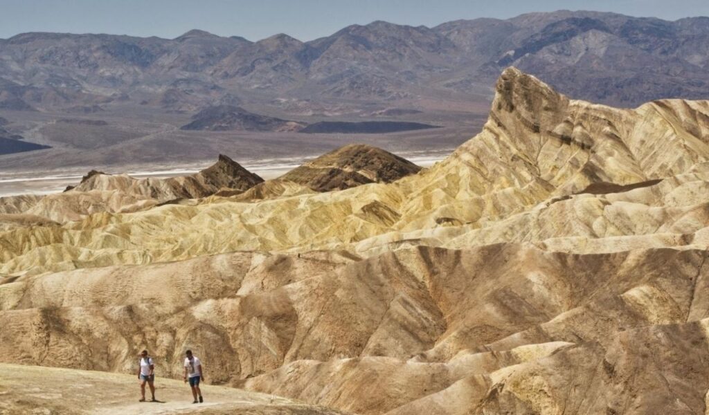
Death Valley pairs extreme heat with geometry that looks engineered.
Badwater Basin sits 282 feet below sea level, and its salt crust fractures into bright white polygons that stretch for miles.
In summer, air temperatures often exceed 120°F, and mirage-like shimmer can make distances hard to judge.
At Racetrack Playa, rocks have been documented moving when thin ice sheets and wind push them, leaving long tracks.
Go at dawn for cooler temperatures and sharper contrast on the valley floor.
Mesquite Flat dunes add another planet effect, and the park’s low humidity helps reveal intense stars on clear nights.
3. Hawaiʻi Volcanoes National Park
Hawaiʻi Volcanoes shows active volcanism in a way few U.S. parks can match.
Kīlauea has erupted repeatedly in recent years, and the park documents how lava flows reshape roads, coastlines, and trails.
Hardened pāhoehoe and ‘a‘ā lava create black, twisted surfaces that look freshly cast.
Steam vents release heat and sulfur gases, and the Halema‘uma‘u area can glow when activity is elevated.
Conditions change fast, so check daily alerts before heading out.
Drive Chain of Craters Road to see lava layers stacked like asphalt, then walk to sea cliffs where new rock meets surf.
Bring rain gear; showers can roll in quickly at higher elevations.
4. White Sands National Park
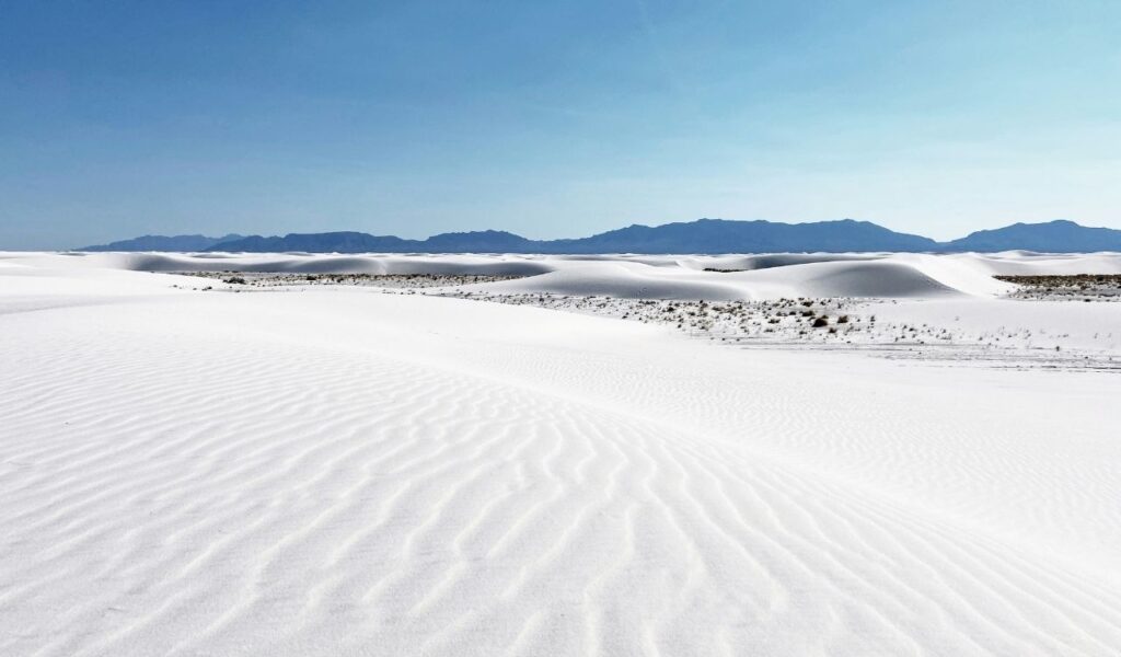
White Sands protects the world’s largest gypsum dune field, built from crystals rather than typical sand.
Gypsum reflects light, so the dunes stay bright white and cooler to the touch than many desert surfaces.
Wind redraws ridgelines overnight, and footprints can vanish within hours, which makes the place feel unreal and temporary.
After rain, the surface firms up, and dune curves appear sharper in photos.
Bring sunglasses and watch children closely, because the uniform color can make bearings confusing.
At sunset, low light paints long blue shadows, and the sky can tint the dunes pink, especially in winter when the air is clear.
5. Crater Lake National Park
Crater Lake fills a caldera left when Mount Mazama collapsed about 7,700 years ago.
At 1,943 feet deep, it is the deepest lake in the United States, and its intense blue comes from clarity and depth rather than algae blooms.
The rim cliffs drop steeply, so the water can look like a colored void rather than a typical lake.
Wizard Island rises from the center as a volcanic cinder cone, reinforcing the impact crater impression.
Summer drives offer full rim views, while winter turns the rim into a snowbound overlook.
No rivers are flowing in or out; the lake is fed mostly by snowfall and rain, with water leaving mainly through evaporation and seepage.
6. Lassen Volcanic National Park
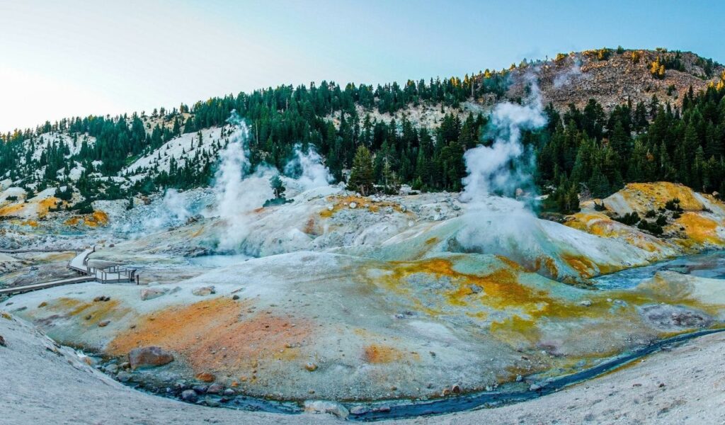
Lassen Volcanic compresses several volcanic landforms into one park, which makes each drive feel like a quick jump between environments.
At Bumpass Hell, boardwalks pass boiling pools, roaring fumaroles, and acidic runoff that stains rock in pale yellows and rust.
Lassen Peak erupted from 1914 to 1917, and the blast zone still shows stripped slopes and lava deposits.
Because trails cross snowfields well into early summer, hikers often carry traction even when nearby meadows are green.
Check air quality during wildfire season in Northern California.
Hydrothermal ground can be thin, so stay on marked paths and keep pets away from hot runoff.