America’s 5 Must-Do Road Trips for Unforgettable Nature Escapes
In the U.S., the best nature road trips aren’t about checking towns off a list.
They’re about watching the country change: rain forest to surf coast, canyon rim to slickrock, prairie sky to tundra.
Each route below has a clear drive plan, dependable pullouts, and nearby hikes or overlooks.
Timing matters too: snow gates, monsoon storms, leaf season, and winter sea conditions can reshape the same road.
Build extra time for short walks, sunrise light, and park-entry logistics, and these drives turn into true resets.
1. Grand Circle Road Trip (Arizona And Utah)
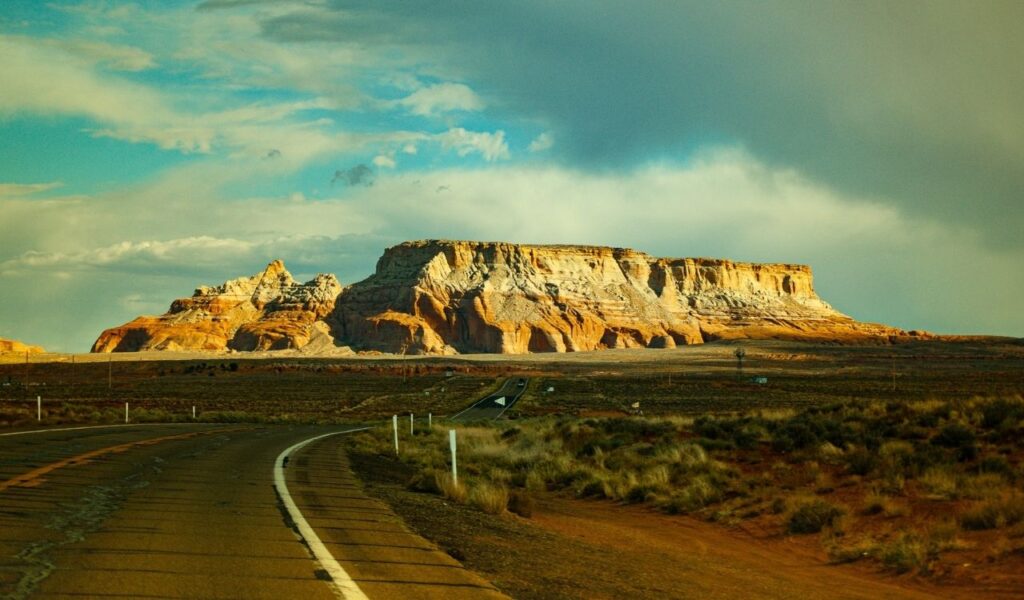
A practical Grand Circle loop often starts in Flagstaff or Las Vegas and covers about 1,000 to 1,300 miles across northern Arizona and southern Utah.
Core anchors include Grand Canyon overlooks, Monument Valley’s buttes on Navajo Nation land, Bryce Canyon’s hoodoos, and Zion’s steep corridors.
Elevation swings are sharp: cool pine air at the South Rim can flip to desert heat within a few hours.
Spring and late fall lower heat stress; summer monsoon storms can bring lightning and flash-flood alerts.
Check Zion shuttle patterns, book popular campgrounds early, and treat sunrise as your best tool for parking and calmer trails.
2. Olympic Peninsula Loop (Washington)
The Olympic Peninsula Loop follows Highway 101 around Olympic National Park, often 350 to 450 miles depending on spurs.
It stacks three settings in one trip: the Hoh Rain Forest’s river paths, Hurricane Ridge’s high overlooks, and Pacific beaches lined with sea stacks.
Lake Crescent adds clear water and easy access to short hikes that still feel secluded.
Late July through September is usually the driest stretch; spring delivers louder rivers and active waterfalls.
Bring layers for sudden fog, watch tide charts for beach walks, and keep an eye out for Roosevelt elk near meadows and trailheads.
3. Florida Keys Overseas Highway (Florida)
The Overseas Highway carries U.S. 1 about 113 miles from Florida City to Key West, including the famous Seven Mile Bridge span.
This trip stays nature-first when stops focus on shoreline, mangroves, and protected water, not nightlife.
Bahia Honda State Park is a reliable base for swimming and beach time; Big Pine Key adds the National Key Deer Refuge for quiet wildlife viewing.
Winter and early spring bring lower humidity and steadier seas, improving snorkeling and boat days.
Check wind forecasts, follow no-wake zones, and time the drive around sunrise for lighter traffic and cleaner light on the flats.
4. Beartooth Highway (Montana And Wyoming)
Beartooth Highway (U.S. 212) runs about 68 miles between Red Lodge, Montana, and Yellowstone’s Northeast Entrance.
It climbs to Beartooth Pass near 11,000 feet, where tundra, snowfields, and alpine lakes sit close to the pavement.
Weather flips fast: a blue-sky start can turn to fog or sleet near the top.
Deep snow closes the route for months, so late June through September is the usual access window.
Services are scarce up high, so top off fuel, pack layers, and watch for mountain goats or marmots near pullouts.
Pull over often on steep grades, and give the brakes time to cool before the long descent.
5. San Juan Skyway (Colorado)

The San Juan Skyway is a 236-mile Colorado loop linking Durango, Silverton, Ouray, and Telluride through the San Juan Mountains.
The signature stretch, the Million Dollar Highway, climbs narrow passes with sharp drop-offs and wide-open views.
Nature access stays close: national forest trailheads, waterfalls, and high overlooks appear often.
Early fall brings strong aspen color; summer adds wildflowers plus afternoon thunder risk at high elevations.
Start mornings early, watch pass forecasts, and take short walks from pullouts to see more than the shoulder.
Hydrate for altitude, and use low gear on long descents.