Chasing Desert Views? 6 Southwest Hikes You Can’t Afford to Miss
Desert views hit different in the U.S. Southwest: sandstone walls that change color by the hour,
canyon rims that drop thousands of feet, and trails where shade is rare, and water is life.
This list favors hikes with clear, high-payoff lookouts across Arizona, Utah, Texas, and California.
For comfort, aim for fall through spring, and watch monsoon forecasts in late summer.
Start at sunrise, pack electrolytes, and respect permit rules that limit crowds on the most fragile routes.
1. Angels Landing, Zion National Park, Utah

Angels Landing is about 5.4 miles round trip with roughly 1,500 feet of climbing from the canyon floor.
After Walter’s Wiggles, the route narrows to a ridge where chains assist on exposed rock.
A permit is required for the final section, which reduces bottlenecks during spring and fall visits.
Grippy shoes matter, and some hikers bring light gloves for the chains.
Carry more water than a normal day hike, because the climb is hot and fully sun exposed.
From the summit, the Virgin River bends through Zion Canyon with massive desert cliffs on every side for miles.
2. The Wave, Vermilion Cliffs National Monument, Arizona
Access is limited by a lottery permit, protecting the fragile sandstone from heavy foot traffic.
The hike is about 6 miles round trip across open desert with no officially marked trail.
Navigation matters: download maps ahead of time, carry a GPS-capable phone, and know your route back.
There is almost no shade, so most visitors aim for cooler months and start at first light.
Midday sun makes the red, orange, and cream bands look vivid, especially after recent rain clears dust.
The payoff is a rolling sandstone bowl of wave-like lines shaped by erosion over millions of years.
3. Lost Mine Trail, Big Bend National Park, Texas

This 4.8-mile round-trip climb in the Chisos Mountains gains elevation fast, then opens to desert scale.
From the upper viewpoints, you can scan ridges, broad basins, and distant peaks toward the Rio Grande.
Parking at the trailhead fills early, so sunrise arrival may decide whether you hike at all.
Fall through spring brings safer temperatures, while summer can be hazardous without careful water planning.
Wind is common on the ridge, so pack a light layer even when the desert floor feels warm.
Stay on the trail to protect desert plants and thin soils that recover slowly after heavy foot traffic.
4. Devil’s Bridge, Sedona, Arizona
This famous red rock hike runs about 2 to 4 miles round trip, depending on where you can park.
Many visitors start from the Dry Creek area, and some trailheads require a rough road that stops low cars.
The last stretch involves a short scramble up sandstone, then a flat walk onto the natural arch.
Sunrise is the smart play: cooler temps, steadier footing, and fewer lines for photos on the bridge.
Views spread across mesas and buttes, with desert vegetation and rust colored cliffs defining the skyline.
Stay back from the edges when winds pick up, and avoid the slickrock if rain makes the route slippery.
5. Hidden Valley Loop, Joshua Tree National Park, California
Near 1 mile, this loop still delivers Mojave Desert visuals: Joshua trees, boulder piles, and open sky.
The path winds through a rock ring that blocks highway noise, so the desert feels quiet.
Visit in winter or early spring for comfortable walking temps; summer heat can be dangerous even on short routes.
Bring sun protection and water anyway, because shade is limited and the air is dry.
Watch for rattlesnakes on rocks, and stay on the trail to protect the fragile desert crust.
For a longer add-on, nearby Ryan Mountain adds elevation and expands the view across the park.
6. South Kaibab To Ooh Aah Point, Grand Canyon National Park, Arizona
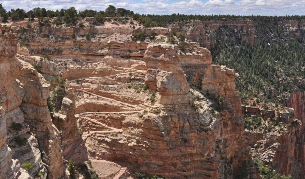
For fast desert scale, this out-and-back is about 1.8 miles round trip with a steep return climb.
There is little shade and no water on South Kaibab, so sunrise is best, especially from late spring through fall.
Ooh Aah Point delivers layered color bands and side canyon views without committing to a long descent.
Yield to mule trains, stay inside the tread on exposed turns, and turn around early if heat builds.
Grippy shoes help on loose gravel, and trekking poles save knees on the climb back up.
South Rim shuttles reduce parking stress during busy holiday weeks.